 Catamaran Cruises in Santorini
The Santorini Caldera: How Big It Is and How It Formed
The Santorini caldera is the flooded crater that gives the island its famous cliff line. It measures about 12 by 7 km and is up to 385 m deep, with villages perched on its rim and two volcanic islets sitting in the middle. This page explains the size and shape of the caldera, how eruptions carved it, and how to see it from the rim or from the water. For the cruise routes themselves, the comparison table on catamaran cruises in Santorini lists every stop.
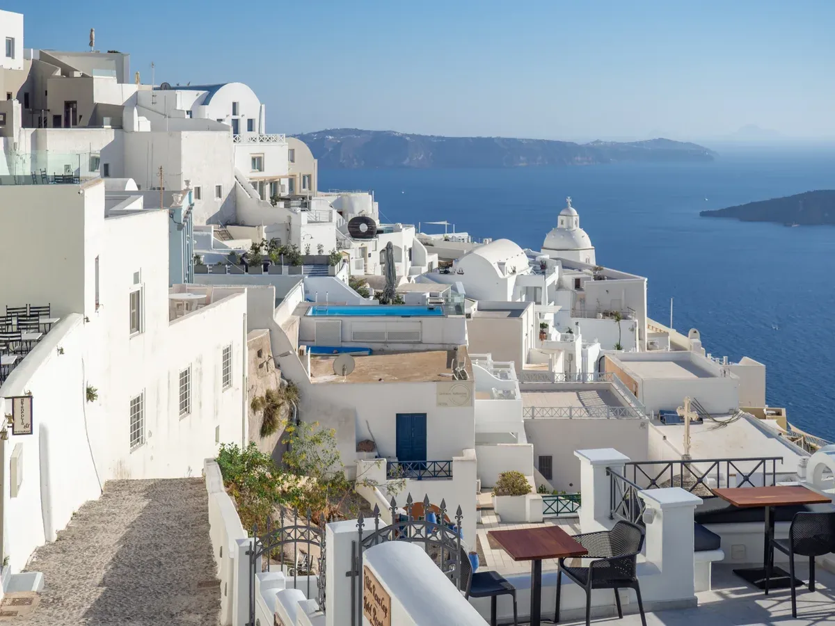
Fira's whitewashed terraces look straight over the caldera. Photo: C messier, CC BY-SA 4.0, via Wikimedia Commons
Quick answer The caldera at a glance
The Santorini caldera measures about 12 by 7 km (7.5 by 4.3 mi) and is up to 385 m (1,263 ft) deep, with cliffs about 300 m high on three sides. It took its present shape about 3,600 years ago in the Minoan eruption, dated to about 1600 BC. Five islands now sit inside it, and the rim villages of Fira, Firostefani, Imerovigli and Oia look down over the water.
Key takeaways
- Walk the rim on the Fira to Oia caldera hike, about 10 km and 3 to 4 hours one way.
- See the whole basin from the water on a small-group catamaran capped at 18 guests, which lists Red Beach, the hot springs and Thirassia among its stops.
- Compare every departure in the comparison table of Santorini catamaran cruises before you book.
- The two volcanic islets in the middle get their own page on the Santorini volcano, including the crater walk.
How Big the Caldera Is
The Santorini caldera is a large flooded crater ringed by cliffs, with a handful of islands inside it. These are the accepted figures from Wikipedia's caldera and geography pages.
Size and Depth in Figures
The caldera is not round. It measures about 12 by 7 km, so it is noticeably longer than it is wide. From the clifftop villages down to the sea there is a drop of more than 300 m at the highest point, and the water below reaches 385 m deep at its maximum. That combination, sheer cliffs on three sides and deep sheltered water in the middle, is what every caldera view in Santorini is built on. The figures in this table come from Wikipedia's Santorini caldera and geography pages.
Santorini itself is a small island with 15,480 residents at the 2021 census, yet a very large number of tourists come to look into this one drowned crater. The main village of the caldera rim is Fira, the capital of the island.
| Measure | Figure | Source |
|---|---|---|
| Caldera dimensions | About 12 by 7 km (7.5 by 4.3 mi) | Wikipedia, Santorini caldera |
| Maximum depth | Up to 385 m (1,263 ft) | Wikipedia, Santorini caldera |
| Cliff height | About 300 m (980 ft) on three sides | Wikipedia, Santorini caldera |
| Main island Thera | About 75.8 km2 | Wikipedia, Santorini caldera |
| Thirasia | 9.3 km2 | Wikipedia, Santorini caldera |
| Nea Kameni | 3.4 km2 | Wikipedia, Santorini caldera |
| Palea Kameni | 0.5 km2 | Wikipedia, Santorini caldera |
| Aspronisi | 650 m long and 200 m wide | Wikipedia, Santorini caldera |
The Islands Inside the Caldera
Five islands sit inside the crater. Thera, the main island, carries the towns and villages. Across the water to the west lies Thirasia, which had 249 inhabitants at the 2021 census. Thirasia was joined to Thera until the Minoan eruption separated the two, and its main village of Manolas holds 140 residents. Its little port of Korfos lies about 270 steps below Manolas.
Then come the three small ones. Nea Kameni and Palea Kameni are the black lava islets in the center, which belong in depth to the Santorini volcano page. Aspronisi, the smallest, is uninhabited. It is 650 m long and 200 m wide, partly made of white pumice, which is where its name, White Island, comes from. It is a nesting ground for some migratory birds. Several cruises pass it, and the Comfort Max Catamaran from Ammoudi lists Aspronisi among its six stops at $67 per person.
How the Caldera Formed
The caldera is the work of millions of years of eruptions, ending in the Minoan event that gave the crater its present shape about 3,600 years ago.
Before the Crater: One Round Island
Volcanism at Santorini spans about 3.5 million years according to the Greek national tourism site, and Topoguide dates the first dacitic lavas near the Akrotiri peninsula to about 2 million years ago. Wikipedia records at least 10 major documented eruptions from 518,000 BC onward. One of them, about 520,000 years ago, ejected about 90 cubic kilometers of material and laid pyroclastic deposits 150 m thick on the seafloor up to 70 km from the vent.
The Greek travel site Nikana describes the pre-eruption island as a round land called Strongili, rising 600 to 1,000 m and built from five merged volcanoes, which it names as Peristeria, Simantiri, Skaros, Thirassia and a central volcano near Akrotiri. Older calderas had already collapsed before this: Wikipedia dates a southern caldera to about 180,000 years ago, a Skaros caldera to about 70,000 years ago and the Cape Riva caldera to about 21,000 years ago, while Topoguide puts the first of them at about 200,000 years. The present basin, though, is much younger.
The Minoan Eruption, About 1600 BC
The Minoan eruption is rated VEI 7. Sources date it slightly differently, so about 1600 BC is the safe way to write it. The eruption column rose an estimated 30 to 35 km into the stratosphere. On Santorini itself the white tephra layer is up to 60 m thick and shows three distinct bands, and ash lay 3 m deep on Anafi, 27 km east.
The tsunamis hit the north coast of Crete 110 km away and are estimated at 35 to 150 m high on arrival, and the eruption destroyed Minoan sites on Crete including Petras and Palaikastro, though the Minoans recovered quickly. On Santorini the Bronze Age town of Akrotiri was buried. No human remains have been found there, which suggests the town was evacuated before the end. Modern excavations began in 1967 under Spyridon Marinatos, and the site lies about 2 km southeast of the modern village of Akrotiri, 15 km south of Fira.
When the eruption emptied the magma chamber, the center of the island collapsed into it, leaving the flooded bowl that exists today. The Kamari Beach hotel blog links the event to the Atlantis legend.
The Kameni Islands Rise in the Middle
The crater did not stay empty. The first Kameni islet broke the surface in 197 BC, and the Roman historian Cassius Dio recorded another small island emerging in 47 CE. Palea Kameni, the old burnt island, was formed by eruptions between 197 BCE and 47 CE, and a submarine explosive eruption near it is recorded in 726 CE. The 1707 eruption then built Nea Kameni, the new burnt island, in the center of the lagoon.
Nea Kameni kept growing through eruptions in 1707 to 1712, 1866 to 1870, 1925 to 1928, 1939 to 1941 and 1950. Wikipedia counts nine recorded subaerial eruptions on the Kameni islands since 197 BC. The last eruption in the caldera was in 1950, a small lava dome extrusion on Nea Kameni. Gas emissions of CO2, SO2 and H2S continue on the islet although the volcano has not erupted in more than 70 years, and a Greek-Italian monitoring station on Nea Kameni records temperatures from surface points and the fumaroles near the summit. Earthquakes are part of the same system: a 7.8 magnitude quake in 1956 killed 53 people on Santorini, collapsed 35 percent of the island's houses, damaged another 45 percent and wrecked much of Oia. An early 2026 sequence of magnitude 3.5 to 5.1 was classed as a typical Aegean seismic swarm, with no evacuation orders and ferries, the airport and hotels running.
Some catamaran routes list the islets, and the Sunset Oia Luxury Open Bar lists Nea Kameni and Palea Kameni among its stops at $124 per person for up to 20 guests. Landing on Nea Kameni and walking the crater rim is a separate trip, covered on the Santorini volcano page.
Sources: Wikipedia, Santorini caldera, Wikipedia, Minoan eruption, Visit Greece
Santorini Greece - Private Caldera Boat Tour
A private boat tour through the Santorini caldera. Third-party video by Santorini Dave. This site did not shoot it and has no relationship with the creator.
The Villages on the Rim and the Caldera Walk
Four villages line the western cliff edge of the Santorini caldera, one after another, from the capital in the south to Oia in the north. A marked footpath joins them all.
Fira and Firostefani
Fira is the capital and seat of Santorini. It sits on the rim with a view across the flooded caldera to the Kameni islands and to Thirassia beyond. South of Fira the rim drops toward the port areas, and Akrotiri village lies 15 km further south with 515 permanent residents at the 2021 census.
Firostefani comes next along the edge to the north. Discover Cyclades calls Firostefani the most practical sunset spot for people staying in Fira without a car, because you simply walk to the railing and wait. The whole cliff line faces the water, so every terrace here is a caldera view by definition.
Imerovigli and Skaros Rock
Wikivoyage calls Imerovigli the highest point of the caldera cliffs. Below the village rises Skaros Rock, a headland carrying the remains of a Venetian castle built in 1207 by Marco Sanudo. Greeka says Skaros was the capital of Santorini until the 18th century and legend holds the castle was never conquered in 600 years.
A 19th-century earthquake ruined it, and only remnants and the Agios Ioannis chapel remain. The Skaros trail from Imerovigli takes about 15 minutes. Santorini Secrets reckons the walk up for sunset is 20 minutes with stairs, and rates the crowds there as moderate compared with Oia.
The Fira to Oia Caldera Hike
This is the walk most people mean by the Santorini caldera hike. It runs about 10 km one way along the rim, and sources time it at roughly 3 to 4 hours. Topoguide marks it as Trail 9, measures 10.2 km with 374 m of ascent and 458 m of descent, and says the route is 71 percent path, 17 percent paved road and 12 percent dirt road.
The high point is Mikros Profitis Ilias at 317 m. The trail passes Firostefani and Imerovigli and the Three Bells, Anastasi, Profitis Ilias and Panagia churches. A Skaros Rock detour adds 45 to 60 minutes.
Oia sits along the northern edge for almost two kilometers at 70 to 100 m above sea level, and is about 11 km from Fira by road.
| Stretch | Distance | Time | Source note |
|---|---|---|---|
| Fira to Oia | 10 to 10.2 km | 3 to 4 hours | Topoguide and Earth Trekkers figures |
| Skaros Rock detour | not stated | 45 to 60 minutes extra | Earth Trekkers |
| Imerovigli to Skaros summit | not stated | 15 to 20 minutes | Greeka and Santorini Secrets |
Oia and the Northern Rim
Oia recorded 838 inhabitants in the community proper at the 2021 census, though the village carries far more visitors on a summer evening. Its Venetian castle from the 15th or early 16th century is the most famous sunset viewpoint on the island, and Santorini Secrets advises arriving 90 to 120 minutes before sunset from May to August, and rates May to July crowds as extreme. The setting point shifts about 50 degrees between solstices, so summer sunsets fall best from Oia while winter ones favor Fira and Akrotiri.
Below Oia lies Ammoudi Bay, a sea-level spot reached by steep stairs or boat. For the volcano islets you can see from these terraces, the dedicated page on the Santorini volcano covers them in depth.
Sources: Wikipedia, Topoguide, Earth Trekkers
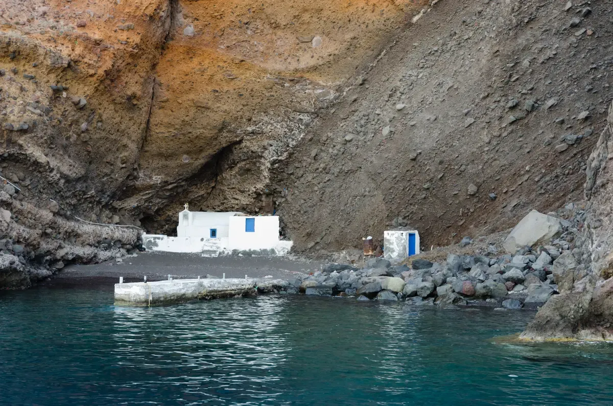
A small white chapel stands at sea level under the crater rim. Photo: Norbert Nagel, CC BY-SA 3.0, via Wikimedia Commons
The Caldera From a Catamaran
From sea level inside the basin, the Santorini caldera looks nothing like it does from the rim. The cliffs rise about 300 meters on three sides.
What the Cliffs Look Like from Below
The caldera measures about 12 by 7 km and drops to 385 m at its deepest, so a boat sits in a flooded crater ringed by cliffs. The cliffs stand about 300 meters high on three sides, over 300 m at their highest point, and the white villages along the top read as a thin bright line. From the water you also see the islands the rim villages face: Nea Kameni at 3.4 km2, Palea Kameni at 0.5 km2, and Aspronisi, an uninhabited strip 650 m long and 200 m wide made partly of white pumice.
Thirassia, 9.299 km2 with 249 inhabitants at the 2021 census, forms the opposite rim. Several cruises list some of them as stops.
Cruises That Circle the Caldera
The Santorini catamaran cruises compared on the homepage all operate inside this basin and along its southern coast. Santorini Star Catamaran takes a maximum of 18 guests on a 5-hour route from Vlychada that lists Red Beach, the hot springs and Thirassia for $111 per person. Caldera Yachting Thirassia runs a semi-private catamaran for up to 16 guests from Ammoudi Bay at $229.06 per person, with a stop on Thirassia itself. Sunset Oia Luxury Open Bar caps its 5 to 6 hour trip at 20 guests for $124 per person and lists Nea Kameni and the Akrotiri lighthouse among its stops. Operators adjust departure and duration through the season because the sunset moves from about 17:05 in late December to 20:40 at the summer solstice. The full comparison, with every boat and price, sits on the catamaran cruise in Santorini overview.
- Red Beach is closed to land access because of rockfall, and the safe way to see its red cliffs is from the water on a boat
- The hot springs swim is a short open-water swim of roughly 50 meters from the boat to warmer orange-brown water
- Free cancellation of 24 hours applies to all the tours listed on this site
Sources: Wikipedia, Santorini Secrets
Caldera Tips: Do and Don't
Five things worth doing on the Santorini caldera rim and four habits to avoid, all drawn from the published figures above.
Do
- Do start the Fira to Oia hike early, because the 10 km rim trail has little shade and Earth Trekkers counts only one snack bar between Imerovigli and Oia, and it is unreliably open
- Do carry more water than you think you need, because the trail runs 71 percent path with 374 m of ascent
- Do take the Skaros Rock detour from Imerovigli, a 15-minute trail to a headland with a castle built in 1207, for 45 to 60 extra minutes
- Do see the caldera from the water as well as the rim, since the 300 m cliffs and the 12 by 7 km basin only read as a whole from sea level
- Do arrive at the Oia castle viewpoint 90 to 120 minutes before sunset in the May to August peak, and Santorini Secrets rates May to July crowds as extreme
Don't
- Don't attempt the rim walk at midday in the hottest weeks, because Earth Trekkers reports little shade on the trail
- Don't try to walk down to Red Beach from the rim side, because the municipality bans approaching it due to rockfall and the safe way to see it is from the water
- Don't plan to buy food or water along the northern half of the hike, because the single snack bar there is unreliably open
- Don't count on a car at sunset, because Discover Cyclades calls Firostefani the most practical sunset spot for people staying in Fira without a car
Santorini Caldera FAQ
How big and how deep is the Santorini caldera?
It measures about 12 by 7 km and reaches 385 m at its deepest, with cliffs about 300 meters high on three sides. The flooded basin and its lava islands are covered in detail on the Santorini volcano page.
How long is the Santorini caldera hike?
The Fira to Oia caldera hike runs about 10 km one way and takes 3 to 4 hours, plus 45 to 60 minutes if you add the Skaros Rock detour. Trail details are in the rim section above and in the Santorini cruise port guide for the cable car and steps at the Fira end.
Which villages sit on the caldera rim?
Fira, Firostefani, Imerovigli and Oia line the western edge, with Imerovigli the highest point of the cliffs and Oia running almost two kilometers along the northern edge. Evening light over these villages is what a Santorini sunset cruise is built around.
What islands lie inside the caldera?
Nea Kameni, Palea Kameni and uninhabited Aspronisi sit in the lagoon, and Thirassia forms the opposite rim with 249 residents at the 2021 census. Boats pass them on the routes compared in the catamaran cruise in Santorini overview.
Is it safe to visit the Santorini caldera?
The island recorded a state of emergency during the 2025 earthquake swarm, with about 11,000 people evacuated, and an early 2026 swarm that brought no evacuation orders while ferries, the airport and hotels kept running. The volcano itself last erupted in 1950, and its monitoring is described on the Santorini volcano page.
Can you see the caldera without hiking?
Yes. Any terrace in Fira, Firostefani, Imerovigli or Oia looks straight across the basin, and a catamaran shows you the 300 m cliffs from below. Shared options start at $67 per person on the Santorini catamaran cruises homepage.